
Mawson Finland Limited Presents Downhole EM (DHEM) Geophysics: Multiple Deep Conductors Newly Identified at Rajapalot
Mawson Finland Limited ("Mawson" or the "Company") (TSXV:MFL) is pleased to announce results from downhole electro-magnetic "DHEM" geophysical surveys conducted at the Rajapalot gold-cobalt project in Finland.
Highlights:
Results and interpretation from downhole EM surveys found multiple deep conductors at Rajapalot
Several strong conductors are located down-dip/down-plunge of both the Palokas and South Palokas zones suggesting gold-cobalt mineralization continues with depth
Additional deep conductors located along-strike from the Palokas Zone, ~500 metres to the north-east
Five conductive targets identified within/nearby to inferred resource area and ready to be drill-tested in this up-coming 2025 winter drill-season
Ms. Noora Ahola, Mawson Finland CEO, states:"We are very excited to report the results of our recent geophysics surveys at Rajapalot. We have identified several exciting targets in downhole EM surveys that suggest the gold-cobalt mineralization at Rajapalot continues with depth at Palokas and South Palokas, while further anomalies are also present in un-drilled areas close-by. We plan to conduct further EM geophysical studies at Rajapalot in the coming weeks in our lead-up to the 2025 winter drilling campaign, in addition to an approximate 600-hectare sub-audio magnetic "SAM" ground-survey presently being carried out over our high-grade Rompas gold project located 6 kilometres east of Rajapalot. We look forward to presenting the results of these additional surveys prior to the initiation of our winter drilling campaign planned to begin in January 2025."
Downhole EM Results
Electromagnetic techniques were first used in 2013 by Mawson at Rajapalot with a helicopter-borne VTEMplus survey indicating the conductive nature of areas subsequently discovered to be the Palokas, South Palokas, The Hut, Terry's Hammer, Rumajärvi, Raja and Joki zones of gold-cobalt mineralization. Due to the close association of gold-cobalt mineralization with pyrrhotite accumulations at the known mineralized occurrences at the Rajapalot project, detection of these sulfide-bearing mineral-systems with EM geophysical methods is achievable due to their associative, highly-reactive EM properties.
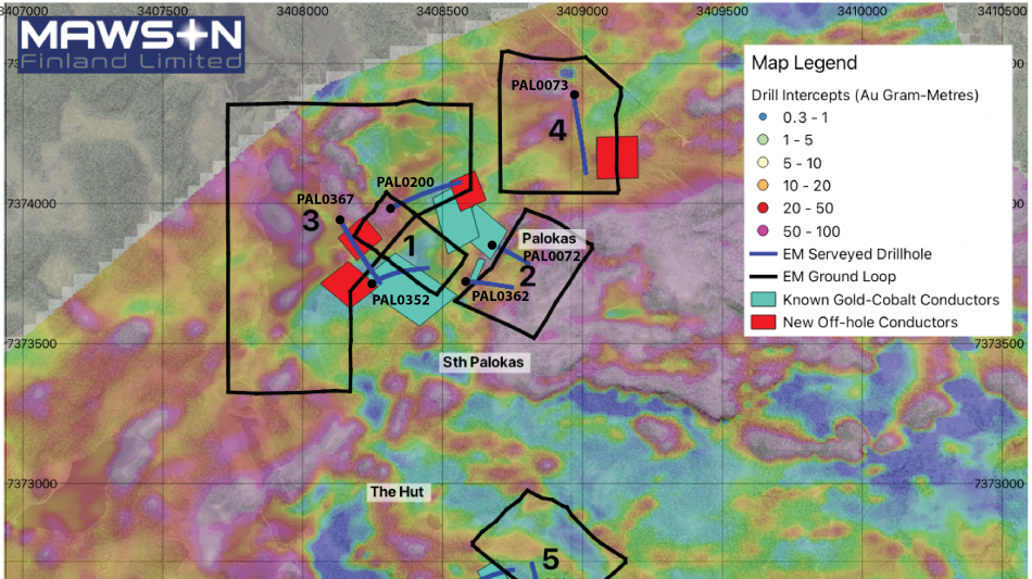
In this downhole EM campaign, five EM-loops were set-out in order to measure conductivity responses in the vicinity of 8 selected drillholes to explore for further nearby gold-cobalt mineralized rock-bodies at Rajapalot (refer to map in Figure 1). Five of 8 drillholes, corresponding to 3-EM loops (loops 1-3), were located around the Palokas and South Palokas zones of gold-cobalt mineralization, while 1 drillhole (loop 4) was located 400 metres north-east of Palokas, and 2 drillholes (loop 5) located on the northern margin of the Raja zone (refer to Figure 1 for drillhole, and EM-loop locations/survey layout).
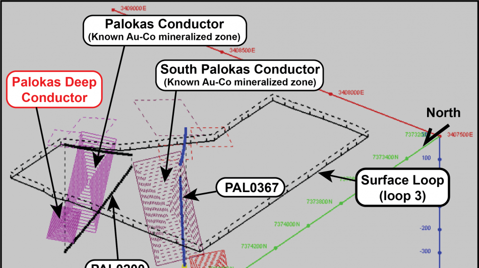
At South Palokas, 2 strong EM conductors were located 'off-hole' to both the north and south of drillhole PAL0367 (loop 3) at the presently defined base of gold-cobalt mineralization. South Palokas conductive body "A" is found to the south of drillhole PAL0367, with the top of the conductor modelled at around -340mRL and continues for some 200 metres in the down-dip direction, while conductive body "B" is located to the north of drillhole PAL0367, with its top modelled at -370mRL and continues for a further 110 metres in the down-dip direction (refer Table 1, and to 3-D projections in Figure 2 and Figure 3). These results strongly suggest that further gold-cobalt mineralization may be present at depth at South Palokas.
At Palokas, a strong EM-conductive body is interpreted on the lower, northern margin of the mineralized zone, extending down-dip from PAL0200 (loop 3), with the top of this conductor modelled at -129mRL, continuing a further 135 metres in the down-dip direction. This modelled conductor initially appears coincident with the lower portions of the deeper areas of the Palokas mineralized zone however, it is interpreted to be separated from the main Palokas mineralized zone. The anomaly isn't readily explained by simply enlarging the presently known geometry of the Palokas mineralized system down-dip with a northerly plunge and as such, these results suggest an additional lens of gold-cobalt mineralization may exist beyond the known limits of mineralization in the deeper areas of the Palokas zone (refer Table 1, and to 3-D projections in Figure 2 and Figure 3).
Two further loops were set-out in the Palokas and South Palokas area in order to search for conductive rocks in between Palokas and South Palokas zones of mineralization (drillhole PAL0352; loop 1), and to search the footwall zone to Palokas in light of the recent discovery of "New Lens" in the footwall area of South Palokas (drillholes PAL0072 and PAL0362; loop 2; refer to Figure 1). No conductive anomalies were observed in these areas beyond that of the signals detected from the known mineralized conductive bodies of both Palokas and South Palokas.
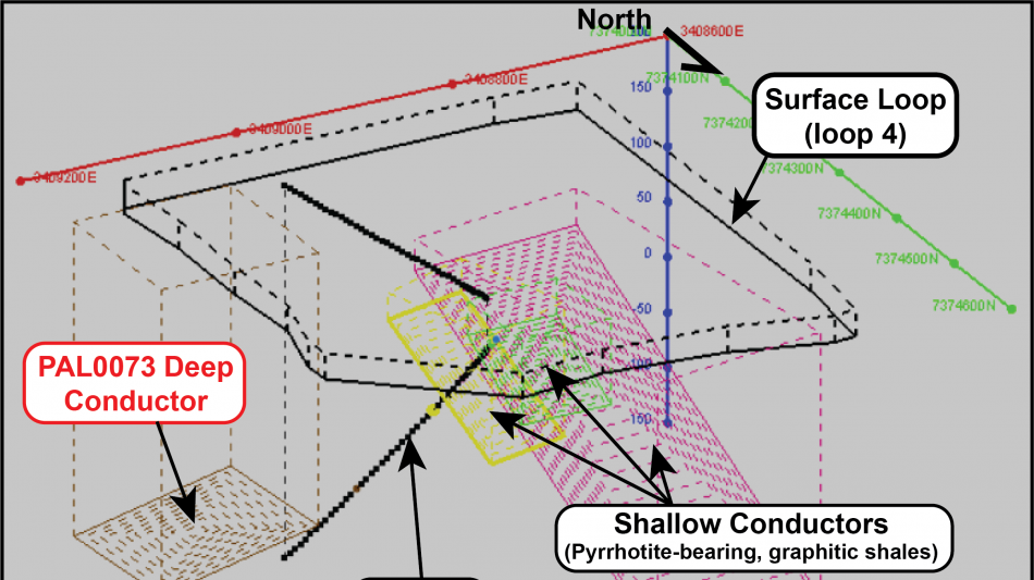
North-east of Palokas, approximately 400 metres along-strike, a further drillhole, PAL0073 (loop 4), was used to measure for the presence of deep conductive anomalies in the vicinity of this drillhole. A strongly conductive, 150m by 150m sized EM anomaly was modelled 'off-hole' to the north of PAL0073, approximately 220 metres below surface at the -50mRL (refer to Table 1, Figure 1, and 3D EM-plate model in Figure 4). These data suggest the presence of a potentially mineralized rock-system located approximately 450 to 600 metres along-strike, to the north-east of the Palokas zone.
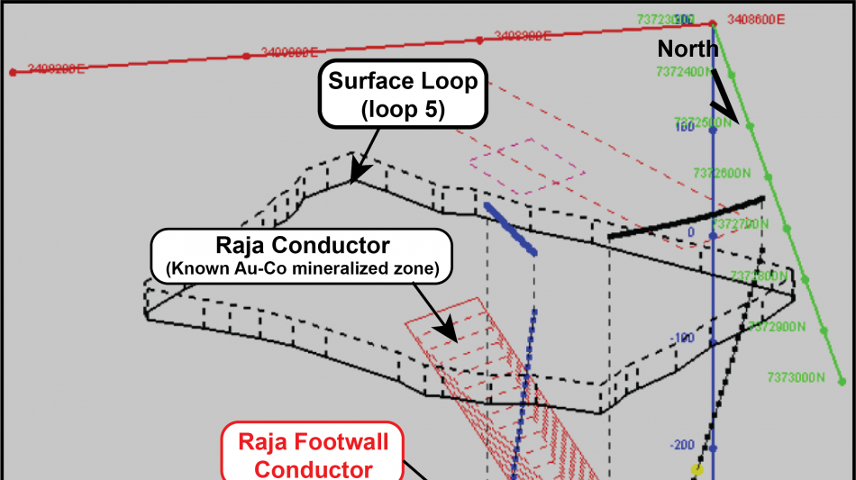
A final loop was set-out in the Raja area, using drillholes PAL0171 and PAL0355 (loop 5; see figure 1). A smaller, 70m by 110m sized, 'off-hole' conductive anomaly was measured on the mid-northern margin of the Raja zone of gold-cobalt mineralization. Modelling of the conductive anomaly places a plate-anomaly in the footwall of the Raja zone of mineralization, only 30 metres below the known zone by approximately (refer to Figure 5). While this general area has received some drilling previously, no drilling has penetrated the specific area defined in the modelled EM plate, and as such presents a very compelling drill-target.
Geophysical Survey Parameters
The downhole EM (DHEM) survey was conducted by Finnish geophysics provider Geovisor Oy from Rovaniemi, using a Zonge ZT-30 transmitter system. The acquisition was measured using the EMIT Smartem24 receiver system with EMIT DHEM Digiatlantis probe that measures the decaying magnetic field with three orthogonal Fluxgate magnetometer sensors producing along hole (A-component), and two perpendicular components (namely U and V- components). For each loop configuration, the base frequency was tested, and the base frequency was altered from 0.25 Hz to 1 Hz. The EM response was stacked over 32,128 EM pulses depending on the base frequency and the observed signal strength. The used time windows scheme was SMARTem standard containing 39 to 43 time channels depending on the base frequency. All the holes were measured in one piece from the collar with surveys having 10 metre reading intervals. The modelling was done using Maxwell software, using plate models. All maps have been created within the KKJ3/Finland Uniform Coordinate System (EPSG:2393).
Technical Background
At Rajapalot, all examples of gold-cobalt mineralization are consistently located within highly-sheared and foliated wall-rocks adjacent to strongly hydrothermally altered, northwest to north dipping shear-zones. Mineralization is typically encountered as disseminated to semi-massive sulfide lenses (predominantly pyrrhotite and lesser pyrite ± cobaltite), hosted within strongly deformed and altered, mafic volcanic and volcaniclasitic stratigraphy of the upper portions of the Paleoproterozoic-aged Kivalo Group of the Peräpohja Greenstone Belt. Prospects with high-grade gold and cobalt mineralization at Rajapalot occur across a 3 km (east-west) by 2 km (north-south) area within the larger Rajapalot project area measuring 4 km by 4 km with multiple mineralized boulders, base-of-till (BOT). Gold-Cobalt mineralization at Rajapalot has been drilled to approximately 470 metres below surface at both South Palokas and Raja prospects, and mineralization remains open at depth across the entire project.
Qualified Person
The technical and scientific information in this news release was reviewed, verified and approved by Dr. Thomas Fromhold, an employee of Fromhold Geoconsult AB, and Member of The Australian Institute of Geosciences (MAIG, Membership No. 8838). Dr. Fromhold is a "qualified person" as defined under NI 43-101. Dr. Fromhold is not considered independent of the Company under NI 43-101 as he is a consultant of the Company.
About Mawson Finland Limited
Mawson Finland Limited is an exploration stage mining development company engaged in the acquisition and exploration of precious and base metal properties in Finland. The Company is primarily focused on gold and cobalt. The Corporation currently holds a 100% interest in the Rajapalot Gold-Cobalt Project located in Finland. The Rajapalot Project represents approximately 5% of the 100-square kilometre Rompas-Rajapalot Property, which is wholly owned by Mawson and consists of 11 granted exploration permits for 10,204 hectares and 2 exploration permit applications and a reservation notification area for a combined total of 40,496 hectares. In Finland, all operations are carried out through the Company's fully owned subsidiary, Mawson Oy. Mawson maintains an active local presence of Finnish staff with close ties to the communities of Rajapalot.
Additional disclosure including the Company's financial statements, technical reports, news releases and other information can be obtained at mawsonfinland.com or on SEDAR+ at www.sedarplus.ca.
Media and Investor Relations Inquiries
Please contact: Neil MacRae Executive Chairman at [email protected] or +1 (778) 999-4653, or Noora Ahola Chief Executive Officer at [email protected] or +358 (505) 213-515.
Neither TSX Venture Exchange nor its Regulation Services Provider (as that term is defined in the policies of the TSX Venture Exchange) accepts responsibility for the adequacy or accuracy of this news release. No securities regulatory authority has reviewed or approved of the contents of this news release.
Forward-looking Information
This news release includes certain "forward-looking information" and "forward-looking statements" within the meaning of applicable securities laws (collectively, "forward-looking information") which are not comprised of historical facts. Forward-looking information includes, without limitation, estimates and statements that describe the Company's future plans, objectives or goals, including words to the effect that the Company or management expects a stated condition or result to occur. Forward-looking information may be identified by such terms as "believes", "anticipates", "expects", "estimates", "aims", "may", "could", "would", "will", "must" or "plan". Since forward-looking information is based on assumptions and address future events and conditions, by their very nature they involve inherent risks and uncertainties. Although these statements are based on information currently available to the Company, and management of the Company believes them to be reasonable based upon, among other information, the contents of the PEA and the exploration information disclosed in this news release, the Company provides no assurance that actual results will meet management's expectations. Risks, uncertainties and other factors involved with forward-looking information could cause actual events, results, performance, prospects and opportunities to differ materially from those expressed or implied by such forward-looking information. Forward-looking information in this news release includes, but is not limited to, the Company's objectives, goals or future plans, any expected receipt of additional assay results or other exploration results and the impact upon the Company thereof, any expected milestone independent data verification, the continuance of the Company's quality assurance and quality control program, potential mineralization whether peripheral to the existing Rajapalot resource or elsewhere, any anticipated disclosure of assay or other exploration results and the timing thereof, the estimation of mineral resources, exploration and mine development plans, including drilling, soil sampling, geophysical and geochemical work, any expected search for additional exploration targets and any results of such searches, potential acquisition by the Company of any property, the growth potential of the Rajapalot resource, all values, estimates and expectations drawn from or based upon the PEA, and estimates of market conditions. Factors that could cause actual results to differ materially from such forward-looking information include, but are not limited to: any change in industry or wider economic conditions which could cause the Company to adjust or cancel entirely its exploration plans, failure to identify mineral resources or any additional exploration targets, failure to convert estimated mineral resources to reserves, any failure to receive the results of completed assays or other exploration work, poor exploration results, the inability to complete a feasibility study which recommends a production decision, the preliminary and uncertain nature of the PEA, the preliminary nature of metallurgical test results, delays in obtaining or failures to obtain required governmental, environmental or other project approvals, political risks, uncertainties relating to the availability and costs of financing needed in the future, changes in equity markets, inflation, changes in exchange rates, fluctuations in commodity prices, delays in the development of projects, capital and operating costs varying significantly from estimates and the other risks involved in the mineral exploration and development industry, and those risks set out in the Company's public documents filed on SEDAR+. Although the Company believes that the assumptions and factors used in preparing the forward-looking information in this news release are reasonable, undue reliance should not be placed on such information, which only applies as of the date of this news release, and no assurance can be given that such events will occur in the disclosed time frames or at all. The Company disclaims any intention or obligation to update or revise any forward-looking information, whether as a result of new information, future events or otherwise, other than as required by law.
SCHEDULE "A" - TABLES AND FIGURES
Loop | Conductor | Drillhole | Conductivity-thickness (s) | Dimensions (Strike x Dip) | Dip/Dip-direction | Depth to top (mRL) |
Loop 1 | NA | PAL0352 | - | - | - | - |
Loop 2 | NA | PAL0072, PAL0362 | - | - | - | - |
Loop 3 | South Palokas Deep "A" | PAL0367 | 100 | 130m x 200m | 48/333 | -340m |
Loop 3 | South Palokas Deep "B" | PAL0367 | 110 | 120m x 110m | 17/314 | -370m |
Loop 3 | Palokas Deep | PAL0200 | 160 | 100m x 135m | 34/330 | -129m |
Loop 4 | Hirvimaa | PAL0073 | 150 | 150m x 150m | 12/103 | -50m |
Loop 5 | Raja Footwall | PAL0171, PAL0355 | 80 | 70m x 110m | 44/326 | -125m |
Table 1: Results from the DHEM survey, with anomaly names and areas listed, their conductance, size, orientation and depth below surface (surface level across survey area is between ~+165m - +175mRL).
SOURCE: Mawson Finland Limited
F.Brown--ThChM