Space-based NASA instrument to track pollution over North America / Photo: © GETTY IMAGES/AFP
A Falcon 9 rocket successfully blasted off from Florida into space on Friday carrying a new NASA device that can track air pollution over North America down to the neighborhood level.
The launch, which took place at 12:30 am (0430 GMT), will bring into orbit the Tropospheric Emissions Monitoring of Pollution (TEMPO) instrument, which will allow scientists to monitor air pollutants and their emission sources more extensively than ever before.
The data will be used by the US Environmental Protection Agency, the National Oceanic and Atmospheric Administration and other agencies responsible for tackling atmospheric pollution.
"TEMPO will be measuring pollution and air quality across greater North America on an hourly basis during the daytime, all the way from Puerto Rico up to the tar sands of Canada," said Kevin Daugherty, NASA's TEMPO project manager.
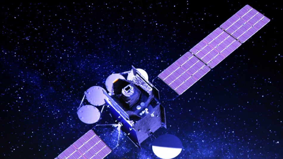
A unique feature of TEMPO, which is about the size of a washing machine and has been described as a chemistry laboratory in space, is that it will be hosted on an Intelsat communications satellite in geostationary orbit.
"Geostationary orbit is a common orbit for weather satellites and communications satellites, but an air quality instrument measuring gases hadn't been there yet," said Caroline Nowlan, an atmospheric physicist at the Harvard & Smithsonian Center for Astrophysics.
Existing pollution-monitoring satellites are in low Earth orbit, which means they can only provide observations once a day at a fixed time.
"We can get measurements, say, over New York City at 1:30 in the afternoon," Nowlan said. "But that's just one data point over New York City over a day.
"The great thing about TEMPO is that for the first time we'll be able to make hourly measurements over North America, so we'll be able to see what's happening over a whole day as long as the sun is up."
In geostationary orbit 22,236 miles (35,786 kilometers) above the equator, TEMPO will match the rotation of the Earth, meaning it will stay over the same location -- North America -- at all times.
TEMPO will be able to measure atmospheric pollution down to a spatial resolution of four square miles (10 square kilometers), or neighborhood level.
Daugherty said TEMPO will power up at the end of May or in early June and begin producing data in October, although it will not be made available to the public until April of next year.
- Multiple applications -
TEMPO will have multiple applications from measuring levels of various pollutants to providing air quality forecasts and helping the development of emission-control strategies.
More than 40 percent of the US population, 137 million people, live in places with unhealthy levels of particle pollution or ozone, according to the American Lung Association, and air pollution is blamed for some 60,000 premature deaths a year.
Among the pollutants tracked by TEMPO will be nitrogen dioxide, produced from the combustion of fossil fuels, formaldehyde and ozone.
The data will be made available online for members of the public to monitor air quality information in their local area.
"Ozone up high is great. It protects us from ultraviolet radiation and allows life to exist on Earth," Nowlan said.
"But when ozone is at the surface, it's a pollutant and it's harmful to humans and also to crops and ecosystems."
TEMPO will also be able to track pollution caused by wildfires, which are becoming increasingly common and damaging as a result of climate change.
The TEMPO device, made by Ball Aerospace, is what is known as a spectrometer.
"It measures the sunlight that's reflected off the Earth's atmosphere and separates it into about 2,000 component wavelengths," said Dennis Nicks, director of payload engineering at Ball Aerospace.
The data is then used to determine the concentrations of trace gases in the atmosphere.
TEMPO will not be alone in its air quality monitoring mission in the Northern Hemisphere.
It will be part of a constellation that includes a South Korean device, GEMS, which has already been launched, and one under development by the European Space Agency, known as Sentinel-4.
J.Liv--ThChM